
5 Surprising Truths About How NYC Really Works, Revealed by Student Deep-Dives into its Community Districts
By Matthew Franchi and Michael Samuelian

When we think of New York City’s governance, the images that come to mind are often monolithic: the decisive actions of the Mayor, the city-wide ballot proposals that shape the five boroughs, and oft-changing MTA weekend service patterns. This top-down view captures the formal structure of power, but it misses a more fundamental truth about how the city actually functions. The real dynamics of New York are intensely hyperlocal, playing out in the unique interplay between its neighborhoods’ physical infrastructure—what urbanists call “hard systems”—and their social and cultural networks, or “soft systems.”
To uncover these overlooked patterns, graduate students in our Urban Systems course at Cornell Tech undertook a new initiative called CDSpec. Over a semester, each student “adopted” a community district (CD), conducting a deep-dive analysis of its “hard” systems (i.e., transit and sanitation) and “soft” systems (i.e., recreation and culture). We designed this project to challenge students to see the city not as a monolith, but as a collection of unique, interacting urban systems. After thoroughly surveying the landscape of their district, students were tasked with envisioning a technical solution to a local issue catalyzed by interactions among contained systems. We’re proud of our students for capturing districts in all five boroughs, compiling statistics, local perspectives, reports, and datasets (courtesy of NYC OpenData) to develop analytical ArcGIS StoryMaps of 21 CDs.
Our students’ findings challenge common assumptions about urban life and offer a more nuanced understanding of the city. To see the full repository of student projects, presented as multimedia ArcGIS StoryMaps, visit the official project website at
https://cdspec.tech.cornell.edu
.
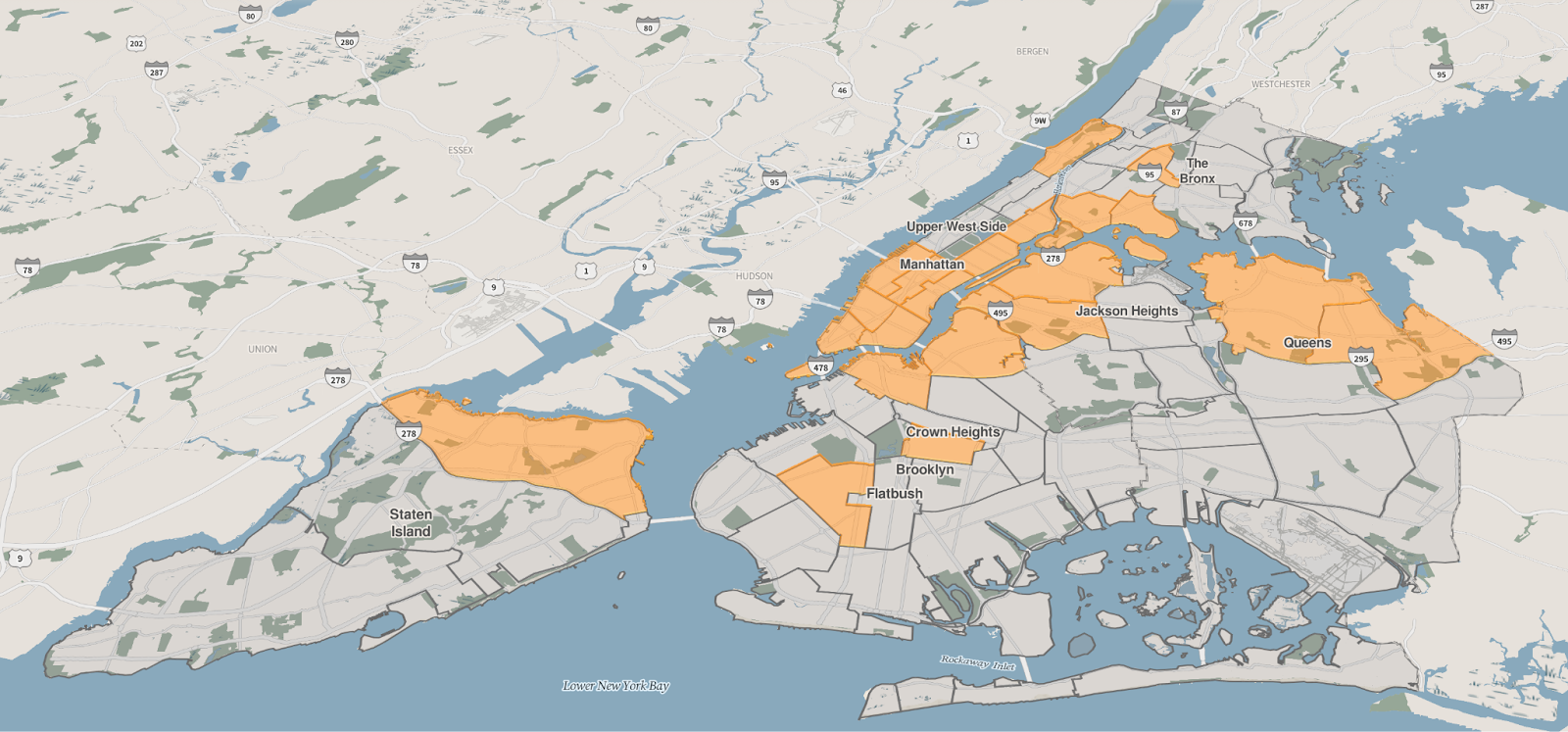
Caption: Highlighted Community Districts were ‘adopted’ by students for the semester. View the map interactively at
https://cdspec.tech.cornell.edu
.
1. There’s a Hyperlocal Layer of Government Hiding in Plain Sight
Beneath the city-wide layer of government, New York has a fascinating and influential system of hyperlocal governance: its 59 Community Districts. These districts serve as a formal bridge between residents and City Hall, giving neighborhoods a direct voice in decisions that affect their daily lives. Each district is represented by a Community Board, a body of up to 50 unpaid volunteers appointed to advocate for their community.
While these boards are advisory—they cannot pass laws or spend money—their recommendations carry significant weight. Their influence is concentrated in three key areas:
Land Use Review: When a developer proposes a significant new building or zoning change, the community board reviews the plan, holds public hearings, and issues a formal recommendation.
Budget Input: Boards submit annual “wish lists” for capital projects (like new parks) and expense priorities (like more sanitation workers), directly influencing how city funds are allocated in their area.
Service Coordination: They act as neighborhood watchdogs, monitoring everything from pothole repairs to trash collection, and coordinating with city agencies to solve local problems.
This system, inspired by advocates like Jane Jacobs, represents a remarkable experiment in face-to-face, participatory governance. In an age of shallow, near-instantaneous digital discourse, this deliberative system, with roots going back 75 years, remains an ongoing experiment in governing a sky-high metropolis at a human scale.
2. If you’re not checking your neighborhood Reddit, you’re missing out
Gabriela Yaulli Herrera’s analysis of CD 402, spanning Astoria, Long Island City, and Woodside, involved digging into r/Astoria, an online Reddit community of over 68,000 members generating thousands of posts and comments a week. She found evidence of neighborhood Reddits being used as a tool for community resistance to hyperlocal issues like the construction of the 31st Street bike lane. These subreddits also serve as virtual bulletin boards, providing answers to questions seeking local recommendations, alerts about safety incidents, and discussions of upcoming infrastructure and policy changes. The New York Groove calls neighborhood subreddits “thriving” and “the last good internet”, highlighting the participatory elements that make them successful: moderation, community rules, non-algorithmic peer upvoting/downvoting, and a pessimistic attitude towards AI slop. See if you can find your neighborhood in this collection of NYC neighborhood subreddits.
3. Artist populations & gentrification
Dingran Dai, in an analysis of Community District 102, covering SoHo, Greenwich Village, and the West Village, ponders the complex profile of resident artists living in New York neighborhoods. As the Manhattan neighborhoods built by artists experience supergentrification – where an already expensive neighborhood becomes exclusively wealthy – the artist class becomes the middleman in a chain of gentrification, pushed into outer neighborhoods like Bushwick, Mott Haven, and Ridgewood and ultimately perpetuating downstream displacement. The situation seems untenable when artists in NYC make, on average, less than the US median wage (Creative New York 2025), and rents in supergentrified neighborhoods continue to skyrocket. Can the city take its longtime resident artists out of the cycle of gentrification?
Dingran highlights the Westbeth Artists Community in the West Village as an example of affordable artist housing; Westbeth employs income qualification and long-term leases to maintain one of the only affordable enclaves for artists in Manhattan. But, Westbeth was established over 50 years ago, and New York has built zero affordable artist housing units in the last decade; in contrast to the over 4,000 units built in other cities across the US in the same time period (Creative New York 2025).
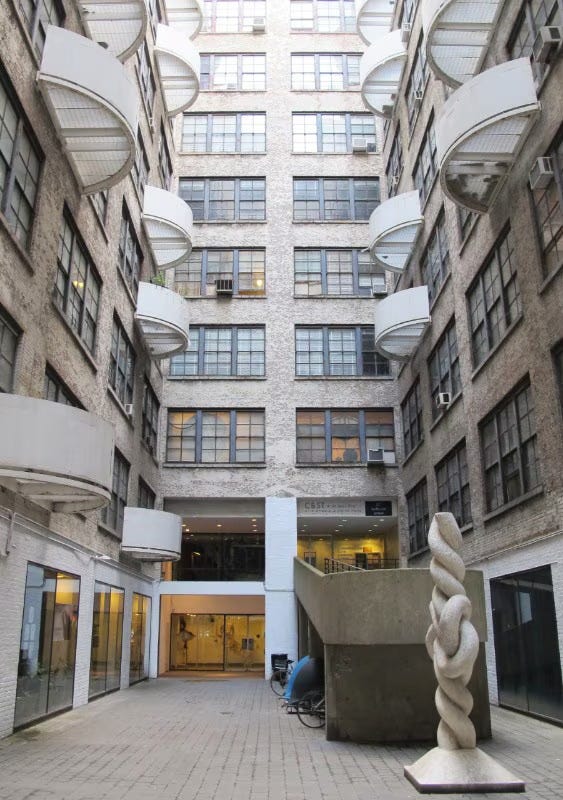
Caption: Westbeth Artists Community, Manhattan. Photo Kurt Hollander
Dingran argues for long-term affordability protections and expanded community land trust ownership. And, thankfully, Westbeth is currently receiving very-much-needed renovations that will bring 32 out-of-use units back to market.
4. If you build it, will they come, and who will leave?
As Edmond Chak Chun Kong notes in his analysis of Queens’ easternmost Community District, CD 411, including Auburndale, Bayside, Douglaston, Douglas Manor, Little Neck, Hollis Hills, and Oakland Gardens, limited access to public transportation in NYC is often assumed to constrain opportunity. So, you might expect CD 411 to be disadvantaged. But Edmond found the opposite. Upon contextualizing the residents of the district, Edmond finds evidence that the neighborhoods in CD 411 are not constrained by the lack of mass transit; nine out of ten households own cars, and American Community Survey (ACS) statistics reveal that the district as a whole is a highly educated and affluent neighborhood. Instead of creating a disadvantage, transit scarcity is linked with affluence. For example, Douglaston Manor, a neighborhood with little to no public transit, boasts the district’s highest median household income at $143,875. As Edmond notes, “Car-based mobility is the norm in CD[4]11, which makes the district’s mobility system shaped as much by infrastructure as by income.”
However, a dominance of car-based mobility reflects current demographic conditions; the district’s makeup is rapidly shifting, with 27% more Asian and Hispanic residents, 24% fewer white residents, and 42% more senior residents. On top of these changes, land use rezonings like Governor Hochul’s New York Housing Compact are set to mandate increased housing density near mass transit stations. Community members in CD411 meet these rezonings with fierce opposition (i.e., ‘not in my back yard!’), anticipating that transit-oriented development will overwhelm the suburban, car-oriented infrastructure. Top-down rezonings can easily clash with the local identity of the neighborhoods within the community district.
And so, while many outer-borough neighborhoods have an active wish list of new mass transit projects (examples including the Interborough Express and QueensLink), some well-established NYC neighborhoods are seeking to preserve their low-density characters; at the forefront of a changing neighborhood is the never-ending question, who has the right to the city?
5. In NYC, Residents Become Their Own Environmental Scientists
It’s been over half a century since the South Bronx was carved apart via the Bruckner Expressway, the Major Deegan Expressway, and the Cross Bronx Expressway. Robert Moses, the architect of those projects, held the belief that “when you operate in an overbuilt metropolis, you have to hack your way with a meat ax.” These developments bear serious consequences, the Cross Bronx Expressway carries more than 300 diesel trucks per hour and is near 110 schools, leading to local children having asthma rates over twice the national average.
Jacey Hu took on Community District 201, spanning Melrose, Mott Haven and Port Morris. She presented on local residents employing citizen science methods to generate crucial data about the extent of ambient air pollution, ultimately using the data to advocate for change and put pressure on policymakers. It started in 2006, when an NYU study provided mobile air pollution monitors (as large as a piece of luggage) to forty 10 to 12 year-old schoolchildren volunteers who took them everywhere they went for a month. The study found that the air the children breathed exceeded the E.P.A.’s air pollution exposure standard on 26% of studied days. This study was groundbreaking, but provided a point estimate; there was still a need for infrastructure that would provide a continuous stream of data.
Enter South Bronx Unite (SBU): a community based-organization and advocacy group with an emphasis on environmental justice, known for establishing a community land trust and advocating against the relocation of FreshDirect to the Harlem River Yards. Since 2012, SBU has developed and installed a system of over 20 air quality monitors, recording extensive data on pollutants like PM2.5, ozone, and nitrogen dioxide. In the era of artificial intelligence, Jacey proposes that a machine learning system be built atop this sensor network, predicting asthma risk hours ahead and providing advance alerts to nearby schools. As shown in Bronx’s Community District 201, New York communities can and will step up with interventions to the built environment when governmental channels are not responsive enough.
In sum, CDSpec was designed to get at the heart of the many facets of urban technology. The lens of urban tech reveals that the city isn’t just a model to be optimized. Rather, technology serves four distinct roles in the modern neighborhood:
Insight: Revealing invisible patterns (like Gabriela’s Reddit analysis).
Transformation: Acting directly on the physical world.
Prediction: Forecasting future states before they happen.
Consensus: Helping disparate groups agree on complex decisions.
We encourage you to check out more student projects at
https://cdspec.tech.cornell.edu
.
Matthew Franchi is a PhD Candidate in Computer Science at Cornell Tech and Michael Samuelian is the Founding Director of the Urban Technology Hub at Cornell Tech.
Fantastic work on the South Bronx air quality monitoring piece. The citizen science angle is underrated - when offical channels lag, locals step up with actual data collection. I've worked on similar grassroots enviromental projects and the pattern is always the same: communities forced to become their own scientists because agencies respond too slowly.